I just want to write a quick summary of some free tools you can use to geotag Nikon RAW files, commonly called NEF files.
A solution I like and that I can 100% guarantee works with NEF files from a D70, D200, D300 and D810, on MY computer, is as follows:
1.) In the field:
Before you start shooting – Make sure your external GPS (eg. Garmin GPSmap 60CS or 60CSx) and camera have their clocks synced.
Turn on your GPS and clip it to something on you or your camera bag, basically something that will go where ever the camera goes and allows the GPS antenna a clear view of the sky. I’ve had good success with clipping to my camera bag and/or pants pocket. Garmin units should automatically be logging a “track” once turned on.
2.) Computer workflow:
I’m on PC and these GPS programs have worked with Windows XP, 7, and now 10.
Get GPS Dump to enable you to extract log files from your Garmin GPS.
Connect the GPS to the PC via USB, open GPSDump and click Garmin(USB), you should see a screen like this:
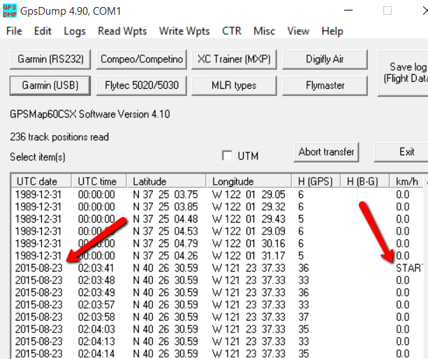
Now select the series of log points you want to use, do this by clicking in the UTC date column, in this example we would start at the line marked START and beginning on 2015-08-23. Using usual multi-select methods highlight all the log points you want to use, then you simply choose File -> Save log As and select a location to save a .gpx log file, eg. My Documents/GPS Logs. Use a name that relates to your photo shoot, eg. “LassenVolcanicNationalPark_082015.gpx”
Get gpicsync to do the actual geotagging.
Once you have your photos downloaded to a location on your computer, open GPicSync, you will see a screen like this:

Fill out the location to your photos and the GPS log file you just created.
Then pay attention to the UTC offset and the time difference to nearest track point. I last used this for photos taken in California (UTC -7) and set a limit on track point offset of 5 mins (300 secs). I am usually on foot for photos and would rather have a vicinity location (5 mins offset) than no location should the GPS have not been able to record a position for some reasons, but you decide what works best for you.
Once you have the settings how you want them hit Synchronise and watch as GPicSync geotags all your photos for you.
DId you find your photos are along the route you took, but they are offset by an hour or 30 mins? This points to your UTC offset being wrong, it’s either wrong because you used the wrong value in GPicSync or your GPS and Camera clocks were not synced/set correctly at the outset. You can go back and figure out the differences if you haven’t changed the camera clock and reset the UTC offset and run again to correct the issue.
Disclaimer: I have had zero problems with file corruption using this method, but use at your own risk, I accept no responsibility for damaged files. I suggest you test this out with a couple of scratch shots before you commit to using it.


 Subscribe to this blog